Path of Hail Storm Visible From Space
(Move your cursor over the image to see the "after" image.)
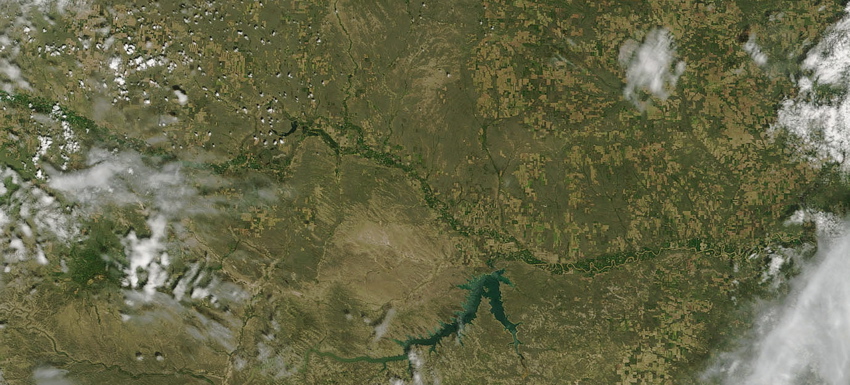
That's going to leave a mark . . .
On June 16, 2007, a high precipitation supercell thunderstorm tracked from near Glacier Park east to the North Dakota border. It caused the most devastating hailstorm to affect the Glasgow area since at least 1999, and prompted 22 severe thunderstorm and 6 tornado warnings in the Glasgow National Weather Service warning area. NASA's Terra* satellite captured the "after" image three days after the storm passed. The storm's path is evident in the image because hail stripped leaves off plants, turning the dark green cropland, pale green natural vegetation, and bright green riverside plants into a strip of tan earth that runs diagonally across the image. The damage is most evident north of Fort Peck Lake, where the hail destroyed bright green vegetation along the Milk River. The tan swath was at least 225 miles long, and up to 12 miles wide. CLICK HERE to see an image with labels.
A bad day on the Hi-Line . . .
The storm began prior to noon near Glacier National Park and gradually moved hundreds of miles eastward over the next several hours. Just before 3 pm, the storm produced a funnel cloud between Harlem and Zurich in Blaine County. The storm continued toward the Glasgow area where baseball size hail and wind gusts in excess of 85 mph were later reported. Torrential heavy rainfall prompted seven flash flood warnings to be issued. The storm eventually weakened near the North Dakota border, just before 10 pm. By this time the supercell had covered approximately 300 miles in nearly 10 hours!
Glasgow and Nashua take direct hits . . .
The most significant damage from the storm occurred in portions of Valley and McCone Counties. The towns of Glasgow and Nashua, both in Valley County, took a direct hit from the storm. In Glasgow, inflow winds out of the southeast had gusted to 60 to 65 mph ahead of the storm bringing down several small tree limbs. These winds then switched to the northwest with gusts in excess of 70 mph accompanied by golfball to baseball size hail. The hail fell for several minutes before diminishing to penny size for another 10-20 minutes. The majority of the homes and businesses in Glasgow had some sort of damage including: broken windows, damaged shingles, dented or broken gutters and skirting. Many vehicles also had significant hail damage. Just the property damage alone in Glasgow amounted to nearly $8.0 million. As the storm continued east it impacted the town of Nashua and every home and business had some form of damage from the baseball size hail and the damaging winds that occurred with it. The winds were measured at 89 mph just west of town. Property damage in Nashua was estimated to be $3 million. In rural areas outside of Glasgow and Nashua there were several cottonwood trees completely uprooted. Horses and cattle were injured by the hail and wind. Montana Fish, Wildlife and Parks reported that many birds and small animals were killed by the hail. There were thousands of acres of alfalfa, wheat, and corn that were completely destroyed. Preliminary damage estimates to crops alone in Valley County totaled $20 million.
Over $30 million in damages. . .
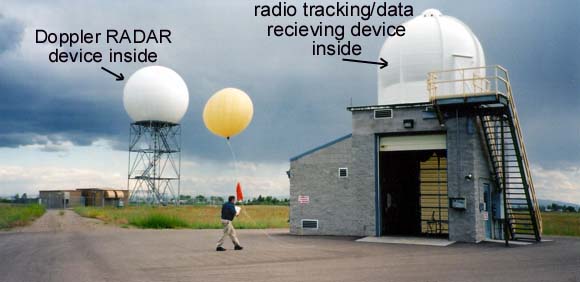
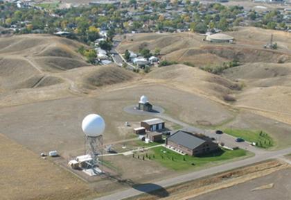
The storm also produced heavy rainfall of 1 to 2 inches, and was followed later in the evening by additional heavy rain. Rainfall of 2 to 7 inches fell in the Antelope, Brazil and Willow Creek basins. The Antelope Creek basin had its most significant flood on record and one road was completely underwater for nearly a third of a mile. One ranch was isolated by the floodwaters for three days. As the storm continued across northern McCone County and into western Richland County it continued to produce hail up to the size of ping pong balls and wind gusts that were estimated as high as 80 to 90 mph knocked down telephone and electrical poles. There was significant damage to farms and ranches in the Vida area, as well as significant loss of crops, estimated at $5 million. The rural nature of the area minimized the property damage that could have occurred. The overall estimated damage in this storm between the hail and wind damage, and the subsequent flooding is 34.2 million dollars. Move your cursor over the image below to see labels: This RADAR image shows the position of the supercell at different stages throughout June 16, 2007. RADAR devices at National Weather Service Offices in Great Falls (KXFT) and Glasgow (KGGW) allowed meteorologists to monitor the thunderstorm and issue timely warnings as it moved across the Hi-Line (county boundaries are shown). The colors on this "reflectivity" image show the intensity of the precipitation. The pink areas are where the most intense precipitation was falling. 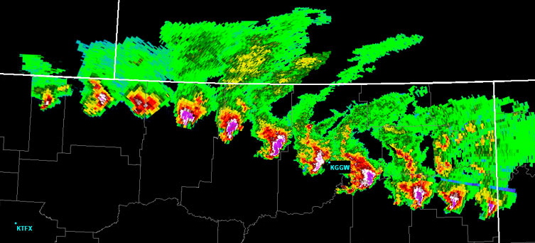
*The NASA images at the top of this page were provided by Liam Gumley, Space Science and Engineering Center at the University of Wisconsin-Madison, using data provided by NASA Goddard Space Flight Center. The images were captured by the Moderate Resolution Imaging Spectroradiometer (MODIS) on NASA's Terra satellite. The article was provided by the National Weather Service Forecast Office in Glasgow, MT. Some editing was done and sub-titles were added.
Term: supercell
|

