|
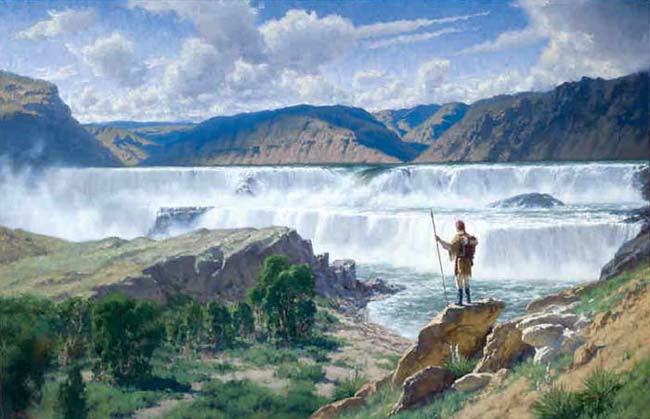
The Arrival of Captain Lewis at the Great Falls of the Missouri, June 13, 1805
 Painting by
Charles Fritz
Oil on Canvas 42" x 65"
An agreeable sound . . .
On the morning of June 11, 1805 Captain Lewis and four men set out from a fork in the Missouri River (now referred to as “Decision Point”) near Loma, Montana in search of “the great waterfalls” that the Indians told them to expect. Clark stayed with the main party and attended to Sacagawea who was ill. The significance of finding the falls is that it confirmed that they had taken the correct fork in the river. Fritz’s painting shows Captain Lewis as he first gazed upon what we now call “The Great Falls” on June 13, 2005. Lewis wrote about the discovery in his journal. I had proceed on this course about two miles with Goodrich at some distance behind me whin my ears were saluted with the agreeable sound of a fall of water and advancing a little further I saw the spray arrise above the plain like a collumn of smoke which soon began to make a roaring too tremendious to be mistaken for any cause short of the great falls of the Missouri. Here I arrived about 12 Oclock. From the reflection of the sun on the sprey or mist which arrises from these falls is a beautifull rainbow produced which adds not a little to the beauty of this majestically grand senery. (Lewis didn’t have spell-check on his laptop.)
A set of five . . .
The Great Falls (shown in the painting) were actually the first of five waterfalls encountered by the explorers as they journeyed through an 18-mile stretch that included the area now occupied by the city of Great Falls. Although each of the waterfalls has its own name (Great Falls, Crooked Falls, Rainbow Falls, Colter Falls, Black Eagle Falls) the set of five waterfalls is referred to as “the Great Falls of the Missouri.”
 Geology caused the falls . . . Geology caused the falls . . .
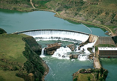
Each of the falls is caused by the presence of an especially tough layer of sandstone unit in the Cretaceous Kootenai Formation. A “formation” is a large area where a particular type of sediment was deposited. The Kootenai Formation consists of sedimentary rocks formed from sands and silts that accumulated in a shallow lake, or as rivers emptied into a marine embayment roughly 115 million years ago. The formation includes alternating layers of siltstone (shale) and sandstone. The city of Great Falls is built on the crest of a gentle fold known as the Sweetgrass Arch. As the arch has been worn down, the sandstone has been more resistant to weathering and erosion, causing the formation of the set of waterfalls that drop the Missouri River more than 500 feet over 18 miles. Click on the Hot Link below that is marked with an asterisk to see a geologic cross-section diagram of the falls area.
Above Right: This aerial photo, provided by Jim Wark of Airphoto - North America, shows the same falls featured in the painting. Ryan Dam, which can be seen just above the waterfalls, is one of five hydroelectric dams that have been built along the Great Falls of the Missouri. Ryan Dam is about 8 miles northeast of the city of Great Falls. To see aerial photos of the other dams
click here and then type “Great Falls” into the box labeled “keyword” (then click “go”).
A month of hard work . . .
The waterfalls on the Missouri River proved to be a huge obstacle for the Corp of Discovery. It took the expedition a month to move everything upstream above the last falls – just 18 miles away. This portion of the journey is known as “The Portage.”
| 
