Image courtesy of Dr. William Bowen
Cal State Northridge
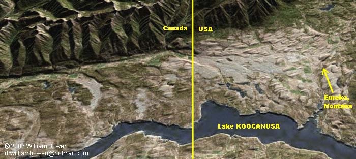
This image shows a portion of the Tobacco Valley in the extreme northwestern corner of Montana. Several tadpole-shaped (teardrop-shaped) hills can be seen in the area between Eureka and the Canadian border. Part of the area is also shown on the topographic map below. The hills resemble a school of tadpoles swimming toward Canada.
One of a kind . . .
The strange hills are called drumlins (photo), and the group shown above, called the "Eureka Drumlin Field", is the only one of its kind in Montana. The swarm consists of over 300 drumlins in an area of 175 square miles around Eureka. The drumlins vary in length from 1,300 feet to 8,000 feet.
Unsolved mystery . . .
A glacier flowed southward through this valley during the last ice age, advancing as far as Polson (about 90 miles from Eureka). As the ice pushed through the area it pulverized bedrock and sediments, forming a mixture of boulders, cobbles, sand, sand and clay called "till". This unsorted mixture of rock materials is what the drumlins are made of. Glaciers transport and eventually deposit till in shapes called moraines, kames, and eskers. In fact the town of Polson sits atop a moraine that helped Flathead Lake to form. Although geologists have a reasonably good understanding of how glaciers build moraines, kames, and eskers, the processes that form drumlins remains somewhat mysterious. It is also poorly understood why drumlins form in some glaciated areas and not in others.
Two schools of thought
. . .
Glaciers remove and transport (weathering, erosion) rock materials from some places, and they deposit these same rock materials in other places (deposition). . . Cirques, u-shaped valleys, and horns are all "erosional features", whereas moraines, kames, and eskers are all "depositional features." Some geologists suggest that drumlins are erosional features, formed when a glacier flowed over deposits of rock material left by an earlier glacier. Others think that drumlins were deposited and shaped simultaneously as a glacier flowed over till that it had transported. Both schools of thought agree that drumlins form beneath an actively flowing glacier, and that the more pointed end of the drumlins indicates the direction that the ice was flowing (toward the south in the case of the Eureka drumlins).
A Bottleneck to blame? . . .
One theory about the formation of the Eureka Drumlins is that the glacier slowed or stagnated upon reaching a narrow portion of the valley 10-15 miles south of Eureka. During warmer periods within the ice age, melting from the bottom and/or front of the glacier may have deposited a significant amount of till in the area. Then, during colder periods the glacier would have started to advance once again, causing thicker ice to flow over the deposits. Pressure from the weight of this somewhat thicker ice may have shaped the rock material into the distinct tadpole-shaped drumlins. Since the till was not deposited and shaped simultaneously, this theory suggests that the Eureka drumlins are "erosional" landforms.
CLICK HERE to see a Google Earth image of the area shown in the map below.
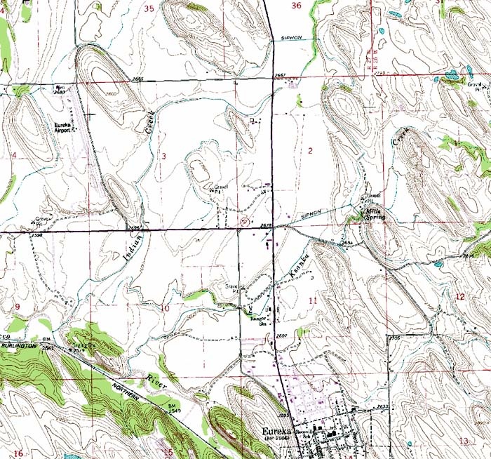 Map Courtesy of USGS and Duane Lund, Montana State Library-NRIS
NOTES . . . 1. The word drumlin comes from the Irish Gaelic word druim, which means "ridge". Perhaps the most famous drumlin is Bunker Hill in Massachusetts. 2. The valley referred to in the text above is known locally as the Tobacco Valley (or Tobacco Plains). It is actually part of "The Rocky Mountain trench", which extends from the St. Ignatius 1,000 miles northwest to the Canada's Yukon Territory. . . .
Term: till
Source
Anderson, Carol. "The Eureka Drumlin Field: Possible Origins." Senior Thesis: University of Montana. June 5, 1978
| 
